|
|
Dolomites Hike 2
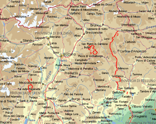
The Alta Via 1 stays largely on about 2.000 m height, through beautiful landscapes of 11 mountain
massifs
The route begins in the northern Tiroler part of the central Dolomites, in the Pusta valley. From
the Pragser Wildsee under the impressive Seekofel, the path gets steeper, to the Porta Sora al Forn.
Goods views here on the surrounding massifs, like the Pelmo and the Tofane. The third day an
alternative route via the Col Bandalsi and Lago Picodel. In the Fanes are nice lakes with many
flowers. Then the route becomes more 'alpine' with less trees, more stones and peaks like the Cime
Campestrin. We camp at Lago di Lagazuoi. Then an alternative path again, over snowfields to the Cima
Lagazuoi, with 2.752 m the highest point on the route.
The Nuvolau is a well known climbing area: on the steep walls of the Cinque Torri are climbers busy
everywhere. On the other side of the valley towers the Tofane majestically between the clouds. The
route descents to a forest and climbs again through nice forest on the Croda da Lago. There we stay
two days in the Rifugio Palmieri along the beautiful lake. The restday-walk without backpack to
Cortina d'Ampezzo is long, nice and peaceful.
After the Forcella d'Ambrissola we pass the Pelmo, again a massive of one piece of Dolomite rock.
The village Pecol has old wooden Tiroler farmhouses. On Passo Duran a restday-climb to the Cima di
San Sebastian (no fun with clouds).
The Belluno Park (Schiara and other massives) at the end is a paradise of rest, blooming trees
and snakes.
Practical route information
Start in Fortezza Villa Bassa > Pragser Wildsee > Rif. Biella > Fedora Fedla > Col Bandalsi > Rif.
La Varella > Forcella del Lago > Lago di Lagazuoi > Rif. di Lagazuoi Picolo > Passo Falzarego > Punte
Rocurto > Rif. Palmieri > Rif. Passo Staulanza > Rif. Palafavera > Rif. Passo Duran > Cime di San
Sebastian > Rif. Pramparet > Biv. Renzo dal Mas > Rif. Bianchet > La Muda > Belluno.
Walking days 12, distance 125 km, average height 1.850 m.
Copyright ©1998/01 Jaap van der Veen
|
|


